AlmeríaCádizCórdobaGranadaHuelvaJaénMálagaSevillaAlpujarra AlmerienseLos VélezComarca Metropolitana de AlmeríaFilabres-TabernasLevante AlmeriensePoniente AlmerienseValle del AlmanzoraBahía de CádizCampiña de JerezCampo de GibraltarCosta NoroesteLa JandaSierra de CádizAlto GuadalquivirCampiña de BaenaCampiña Sur CordobesaLos PedrochesCórdoba (comarca)SubbéticaValle del GuadiatoValle Medio del GuadalquivirAlpujarra GranadinaComarca de AlhamaComarca de BazaComarca de GuadixComarca de HuéscarComarca de LojaCosta GranadinaLos MontesValle de LecrínVega de GranadaEl AndévaloEl Condado de HuelvaCosta OccidentalCuenca MineraComarca Metropolitana de HuelvaSierra de HuelvaÁrea Metropolitana de JaénCampiña de JaénEl Condado (Jaén)La LomaSierra de CazorlaSierra MáginaSierra MorenaSierra de SeguraSierra Sur de JaénLas VillasComarca de AntequeraLa AxarquíaGuadaltebaCosta del Sol OccidentalMálaga Costa del SolNorormaValle del GuadalhorceSerranía de RondaSierra de las NievesAljarafeBajo GuadalquivirCampiña de CarmonaCampiña de Morón y MarchenaComarca de ÉcijaComarca Metropolitana de SevillaSierra Norte de SevillaSierra Sur de SevillaVega del GuadalquivirAlmeríaCádizCórdobaGranadaHuelvaJaénMálagaSevillaAlpujarra AlmerienseLos VélezComarca Metropolitana de AlmeríaFilabres-TabernasLevante AlmeriensePoniente AlmerienseValle del AlmanzoraBahía de CádizCampiña de JerezCampo de GibraltarCosta NoroesteLa JandaSierra de CádizAlto GuadalquivirCampiña de BaenaCampiña Sur CordobesaLos PedrochesCórdoba (comarca)SubbéticaValle del GuadiatoValle Medio del GuadalquivirAlpujarra GranadinaComarca de AlhamaComarca de BazaComarca de GuadixComarca de HuéscarComarca de LojaCosta GranadinaLos MontesValle de LecrínVega de GranadaEl AndévaloEl Condado de HuelvaCosta OccidentalCuenca MineraComarca Metropolitana de HuelvaSierra de HuelvaÁrea Metropolitana de JaénCampiña de JaénEl Condado (Jaén)La LomaSierra de CazorlaSierra MáginaSierra MorenaSierra de SeguraSierra Sur de JaénLas VillasComarca de AntequeraLa AxarquíaGuadaltebaCosta del Sol OccidentalMálaga Costa del SolNorormaValle del GuadalhorceSerranía de RondaSierra de las NievesAljarafeBajo GuadalquivirCampiña de CarmonaCampiña de Morón y MarchenaComarca de ÉcijaComarca Metropolitana de SevillaSierra Norte de SevillaSierra Sur de SevillaVega del Guadalquivir

New Caminito del Rey bridge lowers temperature and reduces trail difficulty

The new 110-meter-long walkway improves thermal conditions and safety on the final stretch of the popular Málaga trail.

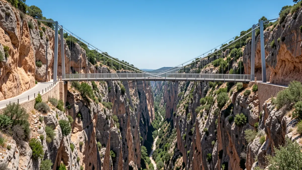
New suspension bridge at the Caminito del Rey, Málaga.
IA

New suspension bridge at the Caminito del Rey, Málaga.

The new Caminito del Rey suspension bridge, measuring 110 meters in length, has opened, offering a route with up to 11.4 degrees less temperature and reducing the physical demands of the final section.

The brand-new suspension bridge at the Caminito del Rey, Spain's longest of its kind at 110 meters, now facilitates the crossing of the final section of the trail, carved into the walls of the Gaitanes Gorge in the province of Málaga. According to a study by the construction company Sando, the new walkway, serving as the southern exit, significantly improves thermal conditions, reduces the required effort, and optimizes evacuation and emergency response capabilities.
Initial comparative measurements, taken over two days, show that the new bridge recorded temperatures up to 11.4 degrees lower than the previous route. The average difference during peak heat hours was 5.8 degrees, as reported by the Málaga Provincial Council. These improvements are particularly crucial during moments of high fatigue for visitors, where heat and accumulated exertion can increase the risk of exhaustion or dehydration.
The preliminary data suggest a consistent trend that reinforces the new route's role in enhancing safety and comfort. The redesign of the final section eliminates one of the most challenging parts of the former route, which involved a series of stairs and a final ascent at a point of high fatigue.
The new itinerary removes nine sections of stairs and approximately 30 meters of elevation gain, maintaining a downward profile and shortening the exit route. These enhancements particularly benefit more vulnerable users, such as the elderly, minors, individuals with reduced mobility, or those with lower physical fitness.
In terms of emergency response, the route now provides more direct access to the area for assistance vehicles. Obstacles such as ascending sections and final stairs have been removed, simplifying the transfer of individuals with injuries or physical limitations and improving the operational efficiency of intervention teams. The Caminito del Rey is located less than 60 kilometers from the city of Málaga, between the municipalities of Ardales, Antequera, and Álora. Before its rehabilitation in 2015, it was considered one of the most dangerous trails in the world.